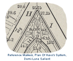
 Also, Plane of Reference. Used in drawing plans
of fortifications to establish definite spatial relationships between projection
lines that mark the locations and boundaries of various features of a
fortification. It is an imaginary horizontal plane that is assumed to pass
above or below the lowest or highest points of elevation that are represented
on a plan. All boundary lines projected on the plan are marked (in feet and
decimal divisions) in reference to their elevation above or below the plane
of comparison. Also, Plane of Reference. Used in drawing plans
of fortifications to establish definite spatial relationships between projection
lines that mark the locations and boundaries of various features of a
fortification. It is an imaginary horizontal plane that is assumed to pass
above or below the lowest or highest points of elevation that are represented
on a plan. All boundary lines projected on the plan are marked (in feet and
decimal divisions) in reference to their elevation above or below the plane
of comparison. |